


NASA, his army of satellites and astronauts aboard the International Space Station took thousands of pictures of our beautiful Earth. From Erupting volcanoes to idyllic islands through the formation of surreal clouds, here is a selection of the best shots.
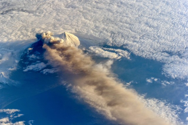
Above, Pavlof volcano in the Aleutian arc erupts in this image captured by astronauts on the International Space Station on May 18, 2013. Below, the eruption plume extends over the Pacific ocean.

A mix of harvested and ripening agricultural fields in eastern Kazakhstan was captured Sept. 9, 2013 by the Landsat 8 satellite, launched this year by NASA and operated by the USGS. (USGS/NASA)

Supertyphoon Haiyan the day before it made landfall in the Philippines. The coast of the Philippines can be seen outlined on the far left of the image. Captured by NASA’s Aqua satellite on Nov. 7 2013.

Running left to right through the center of this image is the scar from the EF-5 tornado that ran through Moore, Oklahoma on May 20, 2013 killing at least 24, injuring 377 and likely topping $2 billion in damages. Captured by NASA’s Terra satellite on June 2, 2013. (NASA).

The Torres del Paine National Park in Chilean Patagonia as captured on Jan. 21, 2013 by NASA’s Earth Observing-1 (EO-1) satellite. (NASA).

Guadalupe Island, located 150 miles off the tip of Baja California is trailed by von Karman vortices in this image captured on by an astronaut on the International Space Station on Aug. 4, 2013. Gravity waves appear in the upper right of the image. (NASA).

This image of Princess Charlotte Bay in Australia was captured by the NASA/USGS satellite Landsat 8 on April 20, 2013. (USGS/NASA).

This image sand dunes in Australia’s Great Sandy Desert was taken by an astronaut on the International Space Station on Mar. 25, 2013. (NASA).

This image of Korangi in coastal Pakistan was taken by an astronaut on the International Space Station on Apr. 20, 2013. (NASA).

This image is a precise recreation of the famous 1968 “Earthrise” photo taken by astronaut William Anders on the Apollo 8 mission. In the new image, the Moon’s surface is based on data from the Lunar Reconaissance Mission, the clouds on Earth are based on the Environmental Science Services Administration 7 satellite from December 24, 1968, and the land surface comes from the Earth Observatory’s Terra MODIS Blue Marble. (NASA)